Posts

SNS and DFS//SNS en DFS – 30 September - 4 October 2019

Image
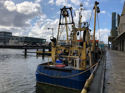
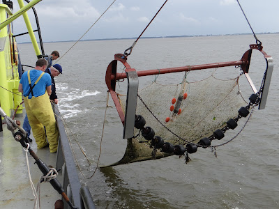
S NS in the North Sea Coastal Zone, and DFS along the Dutch west coast// SNS in de Noordzeekustzone en DFS langs de Nederlandse westkust Isis waiting to sail away, in Scheveningen harbour. Isis ligt in de haven van Scheveningen te wachten om uit te varen. Photo U. Beier. This year’s coastal surveys (SNS and DFS) are finished! (Maybe SNS will have a blog of its own in the future.) Hereby a post with flashes from both of these: De kustsurveys (SNS en DFS) van dit jaar zijn voltooid! (Misschien heeft SNS in de toekomst een eigen blog.) Hieronder een bericht met enkele ervaringen van een week met beide surveys: Cruise leader Thomas Pasterkamp, Wageningen Marine Research, and I, the crew with Gilles (skipper), Gijs, Rob, Dirk, Jeroen, and Huig, stepped on board the Isis in Scheveningen harbour on Monday morning. Our task was twofold. During this week, we were to collect the last three hauls of the SNS outside the Waddenzee islands Texel, Vlieland, and Terschelling, and to start

Easter Scheldt//Oosterschelde – 16-19 September 2019

Image
Underneath the surface of the largest national park in the Netherlands //  Onder het oppervlak van het grootste nationale park van Nederland The Easter Scheldt is a large estuary and tidal area in southern Netherlands, well known for the Oosterscheldekering, a 9 km long dam with storm surge barriers designed to protect from flooding from the North Sea. Its underwater world is famous for having large amounts of oysters, mussels, crabs, lobsters, clams, flatfish, and shrimp, as well as seals, and harbour porpoises. Cuttlefish come here to mate, and several migrating species may pass by or stay in the area. On board the Luctor for the DFS in the Oosterschelde. Aan boord van de Luctor voor de DFS in de Oosterschelde. Photo: U. Beier De Oosterschelde is een groot estuarium en getijdengebied in Zuid-Nederland, bekend om de Oosterscheldekering, een 9 km lange dam met stormvloedkeringen ontworpen om te beschermen tegen overstromingen vanuit de Noordzee. De onderwaterwereld staat bek

Western Wadden Sea//Westelijke Waddenzee – 2-6 September 2019

Image
The ever changing Wadden Sea. De steeds veranderende Waddenzee. Photo: U. Beier For a beginner like me in Wadden Sea field sampling, the week was both intense and impressive. On Monday, Marcel de Vries (cruise leader), the crew and myself (Ulrika Beier) went on board research vessel “Stern”, a former mussel cutter, in Harlingen East harbour. After preparations we could steer towards the Wadden Sea, first passing through the Tsjerk Hiddes locks. Two beamtrawls of 3 m were lying on deck, each for use on the side which was best. The lines for the planned hauls are marked on a digital sea map. Voor een beginner zoals ik op het gebied van bemonstering in de Waddenzee was de week zowel intensief als indrukwekkend. Op maandag gingen Marcel (reisleider), de bemanning en ikzelf aan boord van het onderzoeksvaartuig "Stern", een voormalige mosselkotter, in de haven van Harlingen Oost. Na voorbereidingen voeren we richting de Waddenzee, eerst door de Tsjerk Hiddes-sluizen. Twee

Demersal Fish Survey (DFS)

Image
Photo: Ingrid Tulp The Demersal Fish Survey (DFS) has been designed to target young flatfish in inshore areas like the Dutch, German and Danish coastal zone, the Dutch Wadden Sea, and the southwestern Dutch Delta. The survey has been carried out each year in September-October, since 1970. The information is primarily collected to use in fisheries management. Moreover, the DFS is an important source of information on the coastal fish fauna in general , which is important to increase our knowledge about the dynamic North Sea ecosystem.  De Demersal Fish Survey (DFS) is ontworpen om een beeld te kunnen geven van de hoeveelheid jonge platvissen en de hoeveelheid garnalen in de Nederlandse, Duitse en Deense kustzone, de Nederlandse Waddenzee en de Ooster- en Westerschelde. De survey wordt sinds 1970 elk jaar in september-oktober uitgevoerd. Deze informatie wordt primair verzameld voor gebruik in het visserijbeheer. Daarnaast is DFS een zeer waardevolle informatiebron over de kust